
Predictive Positioning for Security Response Services
A response vehicle can only help reduce journey time if it is in the right area before the call arrives. GMS Cloud Predictive Positioning turns your own response history, live keyholding estate, service-level performance and current risk information into practical guidance showing where available mobile officers should consider waiting between assignments.
Instead of relying on habit, a fixed base or a controller's best guess, the system uses operational heat maps to identify the geographic pattern of likely demand for each day and hour. It can balance those historic activations against the sites you protect, apply additional weight to operational priorities and produce clear regional positioning suggestions that remain easy for controllers and officers to understand.
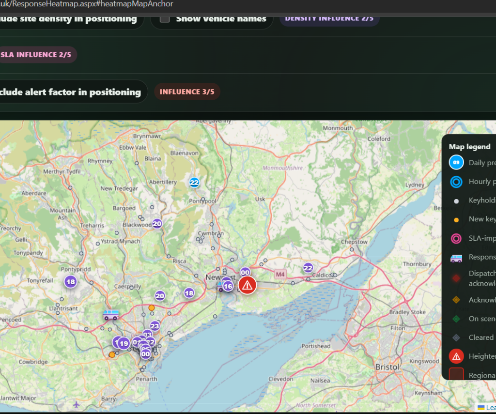
Turn Response History into Practical Positioning Guidance
Every completed response adds to the operational picture. GMS analyses where calls have occurred, when they occurred and which operating region they belong to. Responses are grouped by weekday and hour so that the suggested position for a Monday morning can reflect a different pattern from a Friday night.
The result is a heat map based on the organisation's own experience rather than a generic national model. Controllers can view the expected daily pattern or focus on one selected hour, then use the suggested point alongside live tasking, traffic, officer welfare and professional judgement.
Heat Maps That Change with the Working Week
Response demand is rarely distributed evenly. Industrial estates, town centres, retail locations and remote sites can produce very different activation patterns at different times. GMS converts that history into geographic hotspots, helping the response team see how the centre of likely demand changes throughout the week.
Day view presents the regional operating pattern across the selected weekday, with compact markers for the relevant hours. Hour view concentrates on a particular day and time, giving each region with suitable data a simple bullseye position without covering the map in unnecessary boxes or statistics.
Each marker can be selected to explain the period, region, historic call volume and any additional factors applied. This makes the recommendation understandable to the people expected to use it and gives managers a clearer basis for reviewing positioning decisions.
Coordinate Response Delivery Across Multiple Regions
A single company may cover several towns, counties or operational divisions, and one central hotspot would not be useful for every vehicle. Predictive Positioning works region by region, allowing each area to develop its own demand pattern and suggested muster point.
Controllers can review all regions together for a wider operational picture or concentrate on the region relevant to a particular patrol. This supports local decision-making while giving a central control room a consistent way to coordinate resources across a larger response network.
Regional boundaries can also be displayed for heightened alerts, helping the team understand where an increased risk applies. The same map can therefore provide strategic coverage across multiple areas while retaining the local context needed for practical deployment.
Weight Different Areas Around Your Operational Priorities
Historic call volume is an important starting point, but it is not the only factor that should influence where a response officer waits. A quiet area may contain a high concentration of contracted sites, an important new customer, a group of locations experiencing repeated SLA pressure or a live security concern that requires closer coverage.
GMS allows the historic position to be adjusted using configurable influence levels. Site density, established SLA-breach pressure and active heightened alerts can each be given an appropriate level of influence, moving the suggested position towards the areas that currently matter most without discarding the underlying response history.
This provides a controlled way to weight geographic priorities differently. The business decides how strongly each factor should affect positioning, while the marker explains which adjustments were applied. It remains an operational tool with visible rules rather than an unexplained instruction from a black box.
Balance Activations Against the Live Keyholding Estate
Historic activations can sometimes pull a suggestion towards one geographic outlier. Predictive Positioning can balance that demand against the density of every active site where keyholding and response services are enabled, helping the recommended location remain useful to the wider contracted estate.
Anonymous site dots show officers the general shape of the estate without adding site names, addresses or customer details to the map. Density influence can be switched on by default, moving each regional suggestion partway towards the geographic centre of the protected sites in that area.
New sites are shown more prominently and receive additional positioning weight during their first 14 days. This gives response teams an opportunity to muster closer during onboarding, helping the business make a strong early impression while the new customer's service settles into the wider operating pattern.
Target Persistent SLA Pressure
A response service should not only prepare for where the next call is likely to occur; it should also learn where travel time has consistently made service delivery more difficult. The optional SLA improvement factor uses established site coordinates and the company's own response records to identify areas with sustained, above-baseline breach pressure.
The calculation is designed to avoid allowing one unusual call or a very small sample to dominate the result. It considers qualifying response volume, compares performance with the tenant-wide baseline and gives greater influence to locations where the evidence shows a repeated travel-related problem.
When enabled, the suggestion moves towards the geographic centre of that pressure. This gives managers a practical way to use existing operational data to improve coverage around difficult postcodes and remote sites without relying on a separate postcode API or an unexplained external model.
React to Heightened Alerts and Emerging Risk
Historic patterns cannot predict every short-term risk. GMS can display active heightened alerts against individual sites and across configured regional boundaries, allowing controllers to see where an emerging security concern may affect the current response plan.
Where alert-led positioning is enabled, the current suggestion can be moved towards alerted sites in the same region. The alert influence is configurable, allowing a serious live concern to have more effect than normal site density while preserving a clear record of why the suggested point changed.
Officers handling a live response can also raise a heightened alert directly from an on-scene or recently cleared call. The site and response reference are carried into the existing alert workflow, making it quicker to turn information discovered during attendance into useful positioning intelligence for the rest of the team.
See Live Vehicles and Response Calls in Context
Prediction is most useful when it sits alongside the current operational picture. Where a supported tracking service is configured, live response units can be displayed on the same map and identified by their registration or configured vehicle name.
Current calls are plotted independently of the predicted positions. Clear colour-coded markers distinguish a dispatched call awaiting acknowledgement, an acknowledged officer travelling to site, an officer on scene and a response cleared within the last 30 minutes.
Selecting a response marker shows the site, assigned officer and vehicle. Where a suitable telephone number is available, the officer's name becomes a direct call link, helping the controller move from geographic awareness to practical coordination without opening several different screens.
Improve Response Delivery Without Removing Judgement
Predictive Positioning is designed to support a controller or mobile officer, not replace them. The suggested point gives the team a consistent, evidence-based place to begin, while the final parking or deployment decision remains with the people who can assess live incidents, traffic, road closures, safe parking, welfare and contractual priorities.
Used throughout a shift, the map can help reduce unnecessary returns to a fixed base, improve coverage between assignments and encourage available patrols to wait closer to likely demand. Across several regions, it gives the control room a common operating picture while still allowing local circumstances to influence each decision.
The result is not a guaranteed response time. It is a practical method of using information the business already holds to make more consistent deployment decisions and create better conditions for responsive service delivery.
Measure Whether Positioning Guidance Is Being Used
A useful prediction should be measurable. The Predictive Positioning Adherence report compares the position of staffed response vehicles with the suggestion that existed at the time, while distinguishing an available patrol from one that is dispatched, travelling or on scene.
Managers can review parked idle time, distance to the nearest stored hotspot and the proportion of available time spent within a defined distance of a suggestion. This helps show whether teams are making practical use of positioning guidance or routinely returning to familiar waiting places.
The report is intended for operational improvement rather than judging one isolated location sample. Position data is assessed as a time-based pattern, and the specialist audit records are automatically retained for no more than 90 days.
Explainable, Secure and Built Around Your Data
The recommendations are produced from each company's own response calls, sites, regions, SLA results and active alerts. Tenant-owned data remains restricted to the correct tenant, and the anonymous keyholding layer deliberately avoids sending customer names, addresses or descriptive site information with its dots.
Each adjustment follows a visible rule and can be explained through the marker details. Controllers can see whether a position is based on historic demand, estate density, SLA improvement or active alerts instead of being asked to trust a result with no operational context.
GMS therefore combines the benefits of data-led positioning with the transparency required for real security operations: your data, your regions, your influence settings and a final decision made by your team.
A Stronger Response Service from Data You Already Hold
GMS Cloud Predictive Positioning brings together information that would otherwise sit in separate incident logs, site records, SLA reports, alert lists and tracking systems. It converts that information into one practical map that can be used by controllers, managers and mobile response teams.
For growing security companies, this means a more structured way to deploy vehicles across multiple regions, stronger coverage around the contracted estate, additional focus on new customers and a clear route for responding to persistent service-level pressure.
Most importantly, it helps the organisation move from asking where an officer usually waits to asking where that officer can provide the greatest operational value now.
Questions? You're Covered
Some common questions about Predictive Positioning in GMS: